

ISRO Plans to Launch GISAT-1 Geo-Imaging Satellite on August 12

Manjil Das, INN/Chennai
Twitter-@SGiggle29 @Infodeaofficial
With the planned orbiting of the geo imaging satellite GISAT-1 on board a GSLV-F10 rocket on August 12, the Indian Space Research Organisation (ISRO) is returning to full launch activity at Sriharikota spaceport. It will be the Bengaluru-based space agency’s second launch in the COVID-19-affected year of 2021. On February 28, ISRO successfully launched the PSLV-C51 mission, which carried Brazil’s earth observation satellite Amazonia-1 as well as 18 co-passengers, some of whom were made by students.
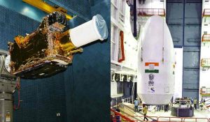
The 2,268-kg GISAT-1 was supposed to launch on March 5 last year from Sriharikota in Andhra Pradesh’s Nellore district, some 100 kilometres north of Chennai, but it was postponed a day before the launch due to technical issues.
Following that, the launch was postponed due to COVID-19-induced lockdown, which disrupted routine operations. It was supposed to happen on March 28 this year, but it had to be postponed due to a “small glitch” with the satellite. The campaign was supposed to start in April or May, but it was cancelled due to a lockdown in areas of the country induced by the second wave of the pandemic.
According to ISRO, GISAT-1 will provide near-real-time surveillance of the Indian subcontinent at frequent intervals under cloud-free conditions.
GSLV-F10 will place GISAT-1 in a Geosynchronous Transfer Orbit, and it will then use its onboard propulsion system to place it in the ultimate geostationary orbit, around 36,000 km above the equator.
The earth observation satellite will give real-time photos of the country’s borders as well as allow for rapid monitoring of natural disasters. Experts say that putting the cutting-edge agile earth observation satellite in geostationary orbit has significant benefits.
“In certain ways, it will be a game-changer for India,” a Department of Space official said. “The satellite’s integrated high-resolution cameras will allow the country to continuously watch the Indian continent and oceans, particularly its borders,” the official said.
ISRO had previously stated that the satellite would deliver near real-time photography of the large area zone of interest at numerous intervals, as part of the mission’s objectives. It would aid in the rapid monitoring of natural disasters, episodic events, and any other short-term occurrences. The third goal is to collect spectral signatures for agriculture, forestry, mineralogy, disaster warning, cloud characteristics, snow and glacier properties, and oceanography.